flowchart LR
    A["Protected<br/>areas"] --> B["3 km buffer<br/>(in meters)"]
    B --> C["Erase all<br/>protected areas"]
    C --> D["Surroundings"]
    A --> E["Inside"]
    D --> F["Merge<br/>'local' field"]
    E --> F
    F --> G["Intersect<br/>with alerts"]
    G --> H["Area in ha<br/>and summary"]
Level Beginner Reading 9 min Data October 2026 Programs ArcGIS 


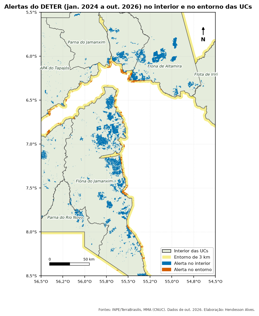
Almost every monitoring report answers the same question: how much of the deforestation (or fire) happened inside the protected area, and how much right next to it? The surroundings matter because that is where the pressure comes from.
In Brazil, protected areas are called Unidades de Conservação (UCs). In the scripts I used, this was done with a protected-area layer that already included the surrounding band, a 0/1 field and an ArcGIS Intersect. Here you will build that layer from scratch and run the overlay in four programs.
What you will do
- Repair the geometries. 830 of the 7,823 alerts in the study area (11%) have invalid geometry, and some programs stop in the middle of the overlay because of it.
- Surroundings: a 3 km buffer around each protected area, minus the area of all protected areas. That way, an alert inside a neighboring area counts as inside that one, not as the surroundings of the other.
- Zones: merge inside and surroundings into a single layer with a
localfield (interiororentorno). - Intersect: cut each alert by the zones. An alert crossing the boundary becomes two pieces.
- Area and summary: area in hectares of each piece, summed by protected area and zone.
Data
Use the articles’ GeoPackage (layers ucs and deter). See how to download it in Articles data.
The code
Variable and field names are in Portuguese, as in the data: ucs = protected areas, entorno = surroundings, faixa = band, zonas = zones, cruzado = overlaid, resumo = summary.
import arcpy

arcpy.env.overwriteOutput = True
gpkg = r"C:\dados\artigos.gpkg"
gdb = r"C:\dados\resultados.gdb"          # create it first with CreateFileGDB

# 0. Copy to memory and repair the geometries
ucs = arcpy.analysis.Select(gpkg + r"\main.ucs", r"memory\ucs", "regiao = 'Amazonia'")
deter = arcpy.management.CopyFeatures(gpkg + r"\main.deter", r"memory\deter")
arcpy.management.RepairGeometry(ucs)
arcpy.management.RepairGeometry(deter)

# 1. Surroundings: 3 km geodesic buffer minus all protected areas
faixa = arcpy.analysis.PairwiseBuffer(ucs, r"memory\faixa", "3000 Meters", method="GEODESIC")
entorno = arcpy.analysis.PairwiseErase(faixa, ucs, r"memory\entorno")

# 2. "local" field and merge of the two layers
arcpy.management.CalculateField(ucs, "local", "'interior'", "PYTHON3", field_type="TEXT")
arcpy.management.CalculateField(entorno, "local", "'entorno'", "PYTHON3", field_type="TEXT")
zonas = arcpy.management.Merge([ucs, entorno], r"memory\zonas")

# 3. Intersect the alerts with the zones
cruzado = arcpy.analysis.PairwiseIntersect([deter, zonas], gdb + r"\deter_interior_entorno")

# 4. Geodesic area in hectares and summary table
arcpy.management.CalculateGeometryAttributes(
    cruzado, [["area_ha", "AREA_GEODESIC"]], area_unit="HECTARES")
arcpy.analysis.Statistics(cruzado, gdb + r"\resumo_interior_entorno",
                          [["area_ha", "SUM"], ["gid", "COUNT"]], ["nome_uc", "local"])
Note
In ArcMap, the Erase tool is only available with an Advanced license. With a Basic license, run a Union of the band with the protected areas and delete the parts that have a protected area. In ArcGIS Pro, use PairwiseErase.
From the menus (Processing Toolbox, Ctrl+Alt+T):
- Fix geometries on the
ucsanddeterlayers. - Reproject layer
ucsto EPSG:5880 (in meters). - Buffer of 3000 m, without dissolving.
- Difference: input = buffer, overlay = protected areas. The result is the surroundings.
- Field calculator on both layers: new field
localwith'interior'or'entorno'. - Merge vector layers and Fix geometries again.
- Intersection: input = alerts, overlay = zones.
- Field calculator:
area_ha=area(transform($geometry, 'EPSG:4674', 'ESRI:102033')) / 10000. - Statistics by categories: field
area_ha, categoriesnome_ucandlocal.
In the Python console (Ctrl+Alt+P), the same steps:
import processing
G = "C:/dados/artigos.gpkg"

def rodar(alg, **p):
    p.setdefault("OUTPUT", "memory:")
    return processing.run(alg, p)["OUTPUT"]

# 0 and 1. Amazon protected areas in meters, 3 km buffer and difference
ucs = rodar("native:extractbyexpression", INPUT=f"{G}|layername=ucs",
            EXPRESSION="regiao = 'Amazonia'")
ucs = rodar("native:fixgeometries", INPUT=ucs)
ucs_m = rodar("native:reprojectlayer", INPUT=ucs, TARGET_CRS="EPSG:5880")
faixa = rodar("native:buffer", INPUT=ucs_m, DISTANCE=3000, SEGMENTS=16, DISSOLVE=False)
entorno = rodar("native:difference", INPUT=faixa, OVERLAY=ucs_m)

# 2. "local" field and merge
interior = rodar("native:fieldcalculator", INPUT=ucs_m, FIELD_NAME="local",
                 FIELD_TYPE=2, FIELD_LENGTH=10, FORMULA="'interior'")
entorno = rodar("native:fieldcalculator", INPUT=entorno, FIELD_NAME="local",
                FIELD_TYPE=2, FIELD_LENGTH=10, FORMULA="'entorno'")
zonas = rodar("native:mergevectorlayers", LAYERS=[interior, entorno], CRS="EPSG:4674")
zonas = rodar("native:fixgeometries", INPUT=zonas)

# 3. Repaired alerts × zones
deter = rodar("native:fixgeometries", INPUT=f"{G}|layername=deter")
cruzado = rodar("native:intersection", INPUT=deter, OVERLAY=zonas,
                OVERLAY_FIELDS=["cnuc", "nome_uc", "local"])
cruzado = rodar("native:deletecolumn", INPUT=cruzado, COLUMN=["fid"])  # see pitfall 3

# 4. Area in hectares and summary
cruzado = rodar("native:fieldcalculator", INPUT=cruzado, FIELD_NAME="area_ha",
                FIELD_TYPE=0, FIELD_PRECISION=4,
                FORMULA="area(transform($geometry, 'EPSG:4674', 'ESRI:102033')) / 10000",
                OUTPUT="C:/dados/deter_interior_entorno.gpkg")
resumo = rodar("qgis:statisticsbycategories", INPUT=cruzado, VALUES_FIELD_NAME="area_ha",
               CATEGORIES_FIELD_NAME=["nome_uc", "local"])
QgsProject.instance().addMapLayers([zonas, resumo])
-- 1 and 2. Zones: inside (the protected area itself) and surroundings (3 km minus all areas)
CREATE TABLE artigos.zonas_ucs AS
WITH ucs AS (
SELECT cnuc, nome_uc, ST_MakeValid(geom) AS geom
FROM artigos.ucs
WHERE regiao = 'Amazonia'
),
todas AS (
SELECT ST_Union(geom) AS geom FROM ucs
)
SELECT cnuc, nome_uc, 'interior' AS local, geom
FROM ucs
UNION ALL
SELECT u.cnuc, u.nome_uc, 'entorno',
ST_Multi(ST_Difference(ST_Buffer(u.geom::geography, 3000)::geometry, t.geom))
FROM ucs u, todas t;
CREATE INDEX ON artigos.zonas_ucs USING gist (geom);
-- 0 and 3. Repaired alerts × zones
CREATE TABLE artigos.deter_interior_entorno AS
WITH deter AS (
SELECT gid, classname, view_date, municipality,
ST_CollectionExtract(ST_MakeValid(geom), 3) AS geom -- 3 = polygons only
FROM artigos.deter
)
SELECT d.gid, d.classname, d.view_date, d.municipality, z.cnuc, z.nome_uc, z.local,
ST_Intersection(d.geom, z.geom) AS geom
FROM deter d
JOIN artigos.zonas_ucs z ON ST_Intersects(d.geom, z.geom)
WHERE NOT ST_IsEmpty(d.geom);
-- 4. Area in hectares and summary
ALTER TABLE artigos.deter_interior_entorno ADD COLUMN area_ha numeric;
UPDATE artigos.deter_interior_entorno SET area_ha = ST_Area(geom::geography) / 10000;
SELECT nome_uc, local, count(*) AS alertas, round(sum(area_ha), 1) AS area_ha
FROM artigos.deter_interior_entorno
GROUP BY nome_uc, local
ORDER BY nome_uc, local;import geopandas as gpd
import pandas as pd
G = "dados/artigos.gpkg"
ucs = gpd.read_file(G, layer="ucs").query("regiao == 'Amazonia'")
deter = gpd.read_file(G, layer="deter")
# 0. Repair geometries, dropping pieces that collapse into lines or points
def corrigir(gdf):
gdf["geometry"] = gdf.make_valid(method="structure", keep_collapsed=False)
return gdf[~gdf.is_empty]
ucs, deter = corrigir(ucs), corrigir(deter)
# 1. Surroundings: 3 km band (in meters, EPSG:5880) minus all protected areas
ucs_m = ucs.to_crs(5880)
entorno = gpd.GeoDataFrame(ucs_m[["cnuc", "nome_uc"]],
geometry=ucs_m.buffer(3000).difference(ucs_m.union_all()),
crs=5880)
# 2. Zones with the "local" field
zonas = pd.concat([ucs_m[["cnuc", "nome_uc", "geometry"]].assign(local="interior"),
entorno.assign(local="entorno")])
zonas = gpd.GeoDataFrame(zonas, crs=5880).to_crs(deter.crs)
# 3. Intersection and area in hectares (equal-area projection)
cruzado = gpd.overlay(deter, zonas, how="intersection", keep_geom_type=True)
cruzado["area_ha"] = cruzado.to_crs("ESRI:102033").area / 10_000
cruzado.to_file("dados/deter_interior_entorno.gpkg")
# 4. Summary table
resumo = (cruzado.groupby(["nome_uc", "local"])
.agg(alertas=("gid", "count"), area_ha=("area_ha", "sum"))
.round(1).reset_index())
print(resumo)Checking the result
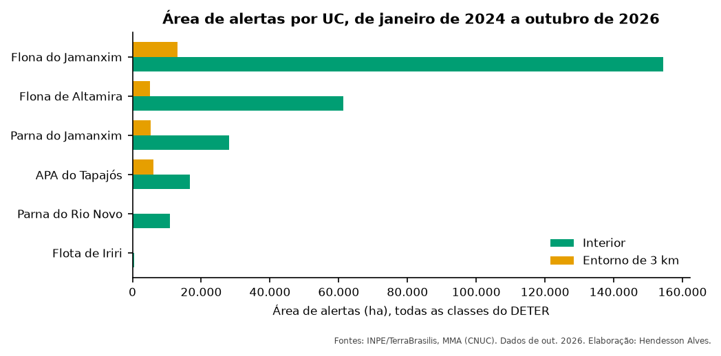
I ran the QGIS, PostGIS and Python versions on the same data (DETER alerts from January 2024 to October 2026). QGIS and Python gave identical numbers. PostGIS came within 0.2%, because it computes the buffer and the area on the ellipsoid, not on a projection.
| Protected area | Inside (ha) | Surroundings (ha) |
|---|---|---|
| Jamanxim National Forest | 154,419 | 13,165 |
| Altamira National Forest | 61,256 | 5,055 |
| Jamanxim National Park | 28,058 | 5,228 |
| Tapajós Environmental Protection Area | 16,750 | 6,106 |
| Rio Novo National Park | 10,924 | 0.1 (see pitfall 2) |
| Iriri State Forest | 467 | — |
Pitfalls
Warning1. Buffer in degrees
SIRGAS 2000 (EPSG:4674) is in degrees. A buffer of 3000 in this coordinate system creates a band 3,000 degrees wide, covering the whole planet. Reproject to meters (EPSG:5880), use ::geography in PostGIS or method="GEODESIC" in ArcGIS Pro.
Warning2. Protected area at the edge of the study area (and slivers)
Rio Novo National Park shows only 0.1 ha of alerts in its surroundings. Checking, 58% of its surrounding band lies outside the area we downloaded: the park is at the edge of the study area, and the alerts there were not downloaded. When downloading data, extend the area by at least the width of the surrounding band.
The 21 remaining pieces are slivers: edges of alerts that lie almost entirely inside a neighboring protected area (the largest is 0.03 ha). For a report, drop pieces smaller than 0.01 ha.
Warning3. Duplicate
fid in QGIS
When saving the intersection to a GeoPackage, QGIS raises UNIQUE constraint failed: fid. An alert cut into two pieces carries the same fid to both. Delete the fid field before saving (native:deletecolumn).
Warning4. Overlapping protected areas
Some protected areas overlap (an Environmental Protection Area may contain a National Forest). In that case the same alert counts as inside both, and the sum over all areas is larger than the deforested area. For an overall total, dissolve the protected areas first, or sum the alert area without the overlay.
Variations
- Outside any protected area, with no distance limit: instead of the buffer, use Erase/Difference between the alerts and the protected areas. That is how I separated burned area “inside” and “outside” protected areas.
- Other distances: 10 km is common for buffer zones of protected areas without a management plan in Brazil (Conama Resolution 428/2010).
See also
- Annual PRODES deforestation in protected areas of the Amazon and the Cerrado
- Course module 3: PostGIS (in Portuguese), with inside and surroundings in SQL, step by step.
Updates
- 2026-10-29: first published, with data from INPE, MMA, IBAMA and SICAR from October 2026.
Reuse
Citation
BibTeX citation:
@misc{alves2026,
  author = {Alves, Hendesson},
  publisher = {Hendesson Alves},
  title = {Inside and Around Protected Areas: The Overlay Every Report
    Uses},
  date = {2026-10-29},
  url = {https://hendesson.github.io/en/articles/02-inside-and-around.html},
  doi = {10.5281/zenodo.23780248},
  langid = {en},
  abstract = {How to separate deforestation inside a protected area from
    deforestation in the 3 km band around it, without double counting
    neighboring areas. Using DETER alerts from 2024 to 2026, the article
    walks through the steps in four programs and four pitfalls that
    showed up with the real data.}
}
For attribution, please cite this work as:
Alves, Hendesson. 2026. “Inside and Around Protected Areas: The
Overlay Every Report Uses.” In Geoprocessing Articles for
Environmental Monitoring. Preprint, Hendesson Alves, October 29. https://doi.org/10.5281/zenodo.23780248.