Level Intermediate Reading 8 min Data October 2026 Programs ArcGIS 


Brazil’s Rural Environmental Registry (CAR) is self-declared: the landholder draws the property. That is why there are properties inside protected areas, including strict-protection ones, where private property should not exist. Knowing where this happens helps prioritize land regularization and enforcement.
The script I used only selected the properties that touched the protected areas. Here you will also measure how much of each property and of each protected area overlaps, which separates the property that only touches the boundary from the one lying entirely inside.
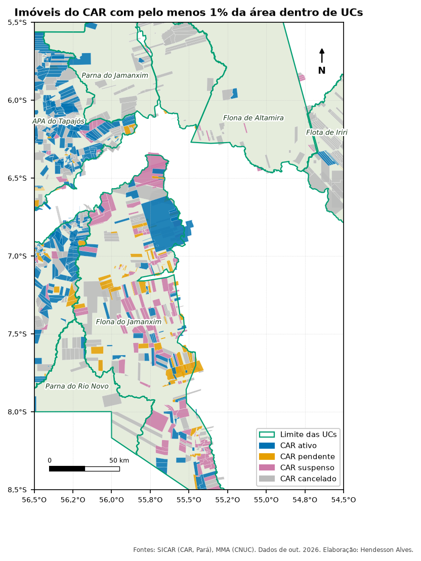
Where the CAR comes from
SICAR publishes the properties of each state in an open WFS service:
- Address:
https://geoserver.car.gov.br/geoserver/sicar/wfs - Layers:
sicar:sicar_imoveis_pa,sicar:sicar_imoveis_mtetc. (one per state)
The most useful fields are cod_imovel (property code), status_imovel (AT active, PE pending, SU suspended, CA cancelled), tipo_imovel (IRU rural property, AST settlement, PCT traditional peoples and communities), condicao (review status) and area (declared area, in hectares). The articles’ script downloads the properties of the study area into the car layer (how to download).
SIGEF (properties certified by INCRA, the land reform agency) works the same way: replace the car layer with the SIGEF one and the code below works unchanged. The files are in INCRA’s Land Archive (https://acervofundiario.incra.gov.br).
What you will do
- Select the properties that touch the protected areas (what the old script did).
- Cut each property by the protected areas and measure the overlapping area.
- Compute the percentage of the property inside the protected area and drop those that only touch.
- Summarize by protected area: number of properties by status and area of the protected area covered by CAR, without double counting properties that overlap each other.
The code
Names in Portuguese: toca = touches, dentro = inside, sobreposicao_ha = overlap in hectares, area_imovel_ha = property area, pct_imovel = percentage of the property, coberta = covered.
import arcpy

arcpy.env.overwriteOutput = True
gpkg = r"C:\dados\artigos.gpkg"
gdb = r"C:\dados\resultados.gdb"
ucs = arcpy.analysis.Select(gpkg + r"\main.ucs", r"memory\ucs", "regiao = 'Amazonia'")

# 1. Select by location (what the old script did)
car = arcpy.management.MakeFeatureLayer(gpkg + r"\main.car", "car")
arcpy.management.SelectLayerByLocation(car, "INTERSECT", ucs)
arcpy.management.CopyFeatures(car, gdb + r"\car_toca_ucs")

# 2 and 3. Intersection, overlapping area and percentage of the property
arcpy.management.CalculateGeometryAttributes(
    gdb + r"\car_toca_ucs", [["area_imovel_ha", "AREA_GEODESIC"]], area_unit="HECTARES")
car_ucs = arcpy.analysis.PairwiseIntersect([gdb + r"\car_toca_ucs", ucs], gdb + r"\car_ucs")
arcpy.management.CalculateGeometryAttributes(
    car_ucs, [["sobreposicao_ha", "AREA_GEODESIC"]], area_unit="HECTARES")
arcpy.management.CalculateField(car_ucs, "pct_imovel",
                                "100 * !sobreposicao_ha! / !area_imovel_ha!", "PYTHON3",
                                field_type="DOUBLE")

# 4. Summary by protected area and status (only properties with at least 1% inside)
dentro = arcpy.analysis.Select(car_ucs, r"memory\dentro", "pct_imovel >= 1")
arcpy.analysis.Statistics(dentro, gdb + r"\car_por_uc",
                          [["cod_imovel", "COUNT"], ["sobreposicao_ha", "SUM"]],
                          ["nome_uc", "status_imovel"])

# Area of the protected area covered by CAR, without counting overlaps between properties
coberta = arcpy.analysis.PairwiseDissolve(dentro, r"memory\coberta", ["nome_uc"])
arcpy.management.CalculateGeometryAttributes(
    coberta, [["coberta_ha", "AREA_GEODESIC"]], area_unit="HECTARES")
import processing
G = "C:/dados/artigos.gpkg"
AREA = "area(transform($geometry, 'EPSG:4674', 'ESRI:102033')) / 10000"
def rodar(alg, **p):
p.setdefault("OUTPUT", "memory:")
return processing.run(alg, p)["OUTPUT"]
ucs = rodar("native:extractbyexpression", INPUT=f"{G}|layername=ucs",
EXPRESSION="regiao = 'Amazonia'")
# 1. Select by location (predicate 0 = intersects)
car = rodar("native:extractbylocation", INPUT=f"{G}|layername=car", INTERSECT=ucs,
PREDICATE=[0])
print("properties touching protected areas:", car.featureCount())
# 2 and 3. Property area, intersection, overlapping area and percentage
car = rodar("native:fieldcalculator", INPUT=car, FIELD_NAME="area_imovel_ha",
FIELD_TYPE=0, FIELD_PRECISION=4, FORMULA=AREA)
car_ucs = rodar("native:intersection", INPUT=car, OVERLAY=ucs,
OVERLAY_FIELDS=["cnuc", "nome_uc", "grupo"])
car_ucs = rodar("native:fieldcalculator", INPUT=car_ucs, FIELD_NAME="sobreposicao_ha",
FIELD_TYPE=0, FIELD_PRECISION=4, FORMULA=AREA)
car_ucs = rodar("native:fieldcalculator", INPUT=car_ucs, FIELD_NAME="pct_imovel",
FIELD_TYPE=0, FIELD_PRECISION=2,
FORMULA='100 * "sobreposicao_ha" / "area_imovel_ha"')
# 4. Summary by protected area and status (at least 1% inside)
dentro = rodar("native:extractbyexpression", INPUT=car_ucs, EXPRESSION='"pct_imovel" >= 1')
resumo = rodar("qgis:statisticsbycategories", INPUT=dentro, VALUES_FIELD_NAME="sobreposicao_ha",
CATEGORIES_FIELD_NAME=["nome_uc", "status_imovel"])
for f in resumo.getFeatures():
print(f["nome_uc"], f["status_imovel"], f["count"], round(f["sum"]))
# Area of the protected area covered by CAR, without counting overlaps between properties
coberta = rodar("native:dissolve", INPUT=dentro, FIELD=["nome_uc"])
coberta = rodar("native:fieldcalculator", INPUT=coberta, FIELD_NAME="coberta_ha",
FIELD_TYPE=0, FIELD_PRECISION=1, FORMULA=AREA)
for f in coberta.getFeatures():
print(f["nome_uc"], "covered by CAR:", round(f["coberta_ha"]), "ha")-- 1 to 3. Properties touching protected areas, overlapping area and percentage of the property
DROP TABLE IF EXISTS artigos.car_ucs;
CREATE TABLE artigos.car_ucs AS
SELECT c.cod_imovel, c.status_imovel, c.tipo_imovel, u.cnuc, u.nome_uc, u.grupo,
ST_Area(c.geom::geography) / 10000 AS area_imovel_ha,
ST_Area(ST_Intersection(c.geom, u.geom)::geography) / 10000 AS sobreposicao_ha,
ST_Intersection(c.geom, u.geom) AS geom
FROM artigos.car c
JOIN artigos.ucs u ON u.regiao = 'Amazonia' AND ST_Intersects(c.geom, u.geom);
ALTER TABLE artigos.car_ucs ADD COLUMN pct_imovel numeric;
UPDATE artigos.car_ucs SET pct_imovel = 100 * sobreposicao_ha / area_imovel_ha;
-- 4. Summary by protected area (only properties with at least 1% inside)
SELECT nome_uc, grupo,
count(*) AS imoveis,
count(*) FILTER (WHERE status_imovel = 'AT') AS ativos,
count(*) FILTER (WHERE status_imovel = 'PE') AS pendentes,
count(*) FILTER (WHERE status_imovel = 'SU') AS suspensos,
count(*) FILTER (WHERE status_imovel = 'CA') AS cancelados,
round(sum(sobreposicao_ha)) AS soma_sobreposicao_ha,
round((ST_Area(ST_Union(geom)::geography) / 10000)::numeric) AS coberta_ha
FROM artigos.car_ucs
WHERE pct_imovel >= 1
GROUP BY nome_uc, grupo
ORDER BY coberta_ha DESC;import geopandas as gpd
G = "dados/artigos.gpkg"
ucs = gpd.read_file(G, layer="ucs").query("regiao == 'Amazonia'")
car = gpd.read_file(G, layer="car")
ALBERS = "ESRI:102033" # equal-area projection
# 1. Select by location
toca = car[car.intersects(ucs.union_all())].copy()
print("properties touching protected areas:", len(toca))
# 2 and 3. Intersection, overlapping area and percentage of the property
toca["area_imovel_ha"] = toca.to_crs(ALBERS).area / 10_000
car_ucs = gpd.overlay(toca, ucs[["cnuc", "nome_uc", "grupo", "geometry"]],
how="intersection", keep_geom_type=True)
car_ucs["sobreposicao_ha"] = car_ucs.to_crs(ALBERS).area / 10_000
car_ucs["pct_imovel"] = 100 * car_ucs["sobreposicao_ha"] / car_ucs["area_imovel_ha"]
# 4. Summary by protected area (at least 1% inside)
dentro = car_ucs[car_ucs["pct_imovel"] >= 1]
resumo = dentro.pivot_table(index="nome_uc", columns="status_imovel", values="cod_imovel",
aggfunc="count", fill_value=0)
resumo["soma_sobreposicao_ha"] = dentro.groupby("nome_uc")["sobreposicao_ha"].sum().round()
resumo["coberta_ha"] = (dentro.dissolve("nome_uc").to_crs(ALBERS).area / 10_000).round()
print(resumo.sort_values("coberta_ha", ascending=False))Checking the result
The QGIS, PostGIS and Python versions gave the same property counts and the same areas (PostGIS differs by less than 0.01%). Since the CAR was only downloaded inside the study area, the percentages refer to the part of each protected area within the study area:
| Protected area | Group | Properties (≥ 1% inside) | Cancelled | Area covered by CAR (ha) | % of the area in the study area | % without cancelled |
|---|---|---|---|---|---|---|
| Jamanxim National Forest | Sustainable use | 415 | 119 | 631,419 | 49% | 37% |
| Tapajós Environmental Protection Area | Sustainable use | 517 | 171 | 511,783 | 72% | 48% |
| Iriri State Forest | Sustainable use | 70 | 63 | 146,701 | 80% | 4% |
| Jamanxim National Park | Strict protection | 89 | 80 | 124,953 | 19% | 2% |
| Rio Novo National Park | Strict protection | 20 | 17 | 51,462 | 17% | 2% |
| Altamira National Forest | Sustainable use | 40 | 29 | 29,644 | 5% | 1% |
The “without cancelled” column changes the story: in Iriri State Forest, 63 of the 70 records have already been cancelled, and coverage drops from 80% to 4%. In the two National Parks (strict protection), 12 active, pending or suspended records remain.
Pitfalls
Selection by location with intersects also picks the property drawn along the protected area boundary, with 0.01% of its area inside. In the study area, 1,196 properties touch the protected areas, but only 1,135 have at least 1% of their area inside. Measure the overlap before concluding that “there are N properties in the protected area”.
Because the CAR is self-declared, several properties cover the same piece of land. Adding up the overlap of each one gives more area than exists: compare the sum column with the covered (dissolved) area in the table above.
Properties with status_imovel = 'CA' (cancelled) remain in the service. Decide whether they enter the analysis and say so in the report. In this article, they appear in a separate column.
SICAR’s public service has neither the name nor the tax ID of the landholder, only the property code. Even so, avoid publishing lists of property codes with accusations: a CAR record overlapping a protected area is a lead for analysis, not a proven violation.
See also
- Inside and around protected areas
- Data sources (in Portuguese), with the CAR, SIGEF and Indigenous Lands
Updates
- 2026-10-29: first published, with data from INPE, MMA, IBAMA and SICAR from October 2026.
Reuse
Citation
@misc{alves2026,
  author = {Alves, Hendesson},
  publisher = {Hendesson Alves},
  title = {Rural Properties {(CAR)} Inside Protected Areas: Selecting
    and Measuring the Overlap},
  date = {2026-10-29},
  url = {https://hendesson.github.io/en/articles/08-car-protected-areas.html},
  doi = {10.5281/zenodo.23780260},
  langid = {en},
  abstract = {Rural properties from the Rural Environmental Registry
    (CAR), downloaded from the public SICAR service and overlaid with
    protected areas, which ones only touch the boundary, which ones are
    inside, and how much of each protected area is declared as a rural
    property. Removing cancelled records changes the conclusion.}
}